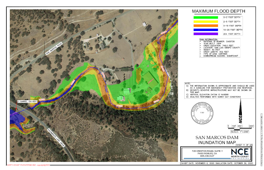
Completed in November 2020, the San Marcos Dam Inundation Map is a new project that NCE is excited to share. The Department of Water Resources requires dam owners to perform a dam breach study every ten years to create an emergency response in case of failure. Our team modeled the breach of a 40-foot tall dam and the impacted area downstream from the dam. The simulation includes 407 acre-feet of water traveling over 10 miles through the San Marcos Creek in just under two hours. NCE was able to map the inundated area in color pdfs for safety officials to prepare an emergency action plan (EAP) in response to a dam failure.
The San Marcos Dam was designed in 1962 and erected in 1966 according to the recorded as-builts. The dam is located off of Chimney Rock Road on Chimney Rock Ranch, approximately 7 miles northeast from Paso Robles. The earthen dam was constructed by raising and filling the existing San Marcos Creek by approximately 50 to 60 feet. The spillway is made of concrete and cut into an existing hill down to bedrock. There is a 55-foot-wide and 12-foot-tall concrete spillway with a capacity of 10,000 cubic feet per second built into the earthen dam.
For more information on this project and a video timeline of the Inundation Mapping, click here to check out our project page!

")
")
Meet Our Team

Greg Jaeger, PE
President & CEO

John Luttman, PE
Vice President & Principal Engineer, QSD/P

Tucker Sanders, PLS
Vice President & Survey Manager
Have a project in mind?
We would love to hear from you and show you what we can do for your next project.
nce@northcoastengineering.com
725 Creston Rd Suite C Paso Robles, CA 93446
+1 (805) 239 – 3127